| Land Patents |
Tehachapi Maps and Air Photos
Those of us who live in Tehachapi are all familiar with "the old road" Woodford Tehachapi Road. Looking at old maps (I have many) I began to wonder what were the routes of the old roads that predated Woodford Tehachapi and State Route 58. I spent a lot of time researching this question, and then I stumbled on the self publish book by Melvin McAllister titled Tehachapi Pass.See this article from The Loop: From this article we know the museum has a copy or two, for in 2021 - using my cell phone I copied a few pages from the book. Marvin did a fantastic job on this book. I have looked many times for it on used book websites but it never shows up. I hope Marvin and his wife (well and the museum) don't mind me sharing the pages that I copied. Click Here To Download a portion of Marvin's Book: Tehachapi Pass
|
These old Federal Government survey plats established the locations of Township and Section Corners.
Eventually all surveys that followed, such as where my home's lot is, all tied to these surveys.
These Township Plats recorded roads, trails, railroads, springs and creeks and some houses.
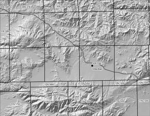
Tehachapi Townships (Vector Google Earth KML file)
General Land Office, Township Plats - Downloads. (Source: www.glorecords.blm.gov)
| Mount Diablo Meridian | Georeferenced PDFs* | Google Earth KML files |
| 31S, 32E (1876) | ||
| 32S, 31E (1854) | ||
| 32S, 32E (1854) | ||
| 32S, 32E (1855) | ||
| 32S, 33E (1854) | ||
| 32S, 33E (1855) | ||
| 32S, 34E (1855) |
| San Bernardino Meridian | Georeferenced PDFs* | Google Earth KML files |
| 11N, 14W (1855) | ||
| 12N, 14W (1855) |
| 1855 Tehachapi Trails | KML | |
| Note: The Tehachapi Trails data was intrepreted from the township plats and other early maps. Due to my uncertainity for some of the routes there are gaps in the lines. The KML file is a line (vector), not a graphic (raster). | ||
| Georeferenced PDFs* | Google Earth KML files | |
| Tehachapi City | KML | |
| Tehachapi City East | KML | |
| Monolith West | KML | |
| Monolith | KML | |
| Proctor Lake East | KML | |
| Tehachapi Old Town | KML | |
| Golden Hills West | KML | |
| Brite Valley | KML | |
| Bear Valley West | ||
| Bear Valley East | ||
| Bear Valley North | KML | |
| Tehachapi Prison | ||
| Cummings Valley North | KML | |
| Cummings Valley West | KML | |
| Stallion Springs | KML | |
| Tehachapi Loop | ||
| Caliente |
| Caliente 1914 | KML | |
| Mojave 1915 |
How to create a high resolution Google Earth ground cover. Sharing some of my lessons learned.
| *The PDF files can be viewed with Adobe Reader, however since they are georeferenced you can down load Avenza (aka PDF maps) to your smart phone to view them as well. Since they are georeferenced, Avenza will display a blue dot to show where you are on the map. |
| **FYI: Except for the Tehachapi Tehachapi Townships, and Trails KML files, the other KML don't open in Google Earth on my Android phone. |
| Larry Vredenburgh larry@vredenburgh.org |